
More background on the EVTOL Flight Weekly post this week
Chasing the ghost of N542AJ

SkyZero.io displays flight data - actual flight should be involved. If you see a flight in the Beta Technologies page at SkyZero.io it is a flight - an aircraft moved, left the ground while switched on.
Not everything we see is a flight - often its just activity.
For instance, at an airshow, the team might switch on the aircraft during a static display. It won’t go anywhere, and its altitude should read “ground” - however, we’ll be getting high precision data about the aircraft while its switched on. Another case of a high precision activity might be an aircraft taxiing, charging, or being pulled around the tarmac by a tug while switched on.
We do see a lot of activity made up entirely of low precision data. While we don’t know what this is, yet, our educated guess is that it happens when an aircraft, of part of it, is switched on, but there is no GPS feed to the ADSB transponder. In this case, the transponder won’t broadcast a coordinate, or may broadcast 0.0,0.0. It’s our understanding that in this case, ground equipment (radar, ADSB transponders participating in an ADSB network) will instead estimate the location, often providing this low precision data at that time.
There are different levels of purposeful or even accidental “stealth” behaviour shown by different OEMs:
Vertical Aerospace confirms that they are not required to turn on ADSB, and so they don’t - they don’t show up at all (that I’ve found yet).
Joby often shows up with coordinates
0,0or low precision coordinates - maybe that the aircraft was turned on but not expected to fly, or was flying in an area where they have some kind of exemption to ADSB rules, or this was equipment testing of some sort.Archer has been known to show up with a “dynamic hex code” and no tail registration; its our understanding this happens when ADSB is fully disabled, forcing ground equipment to assign a hex code to the aircraft. When this happens the hex code will be prefixed with a ~ (tilde) character. If there are enough receivers online, this may result in high precision data (thanks to MLAT), if not precision will remain low.
Harbour Air and FlyOnE in Australia have both explained to me that they enable ADSB only when its required; either to avoid needing to purchase extra equipment or simply turning it off when its not required by local regulation (we have encouraged them both to turn on ADSB all the time!)
How we decide what to show on skyzero.io
We only show flights in the flight log listings on the page specific to a given OEM or a given airport. This is partially to prevent the visitor from accidentally trying to view a flight that doesn’t have any high precision data or never leaves the ground.
In the skyzero.substack.com EVTOL Flights Weekly email analysis, we separate out stats activity vs flights. In the past, we only included high precision activity, though recently we’ve begun to suspect that there might be some value in the low precision activity, given that it might indicate something.
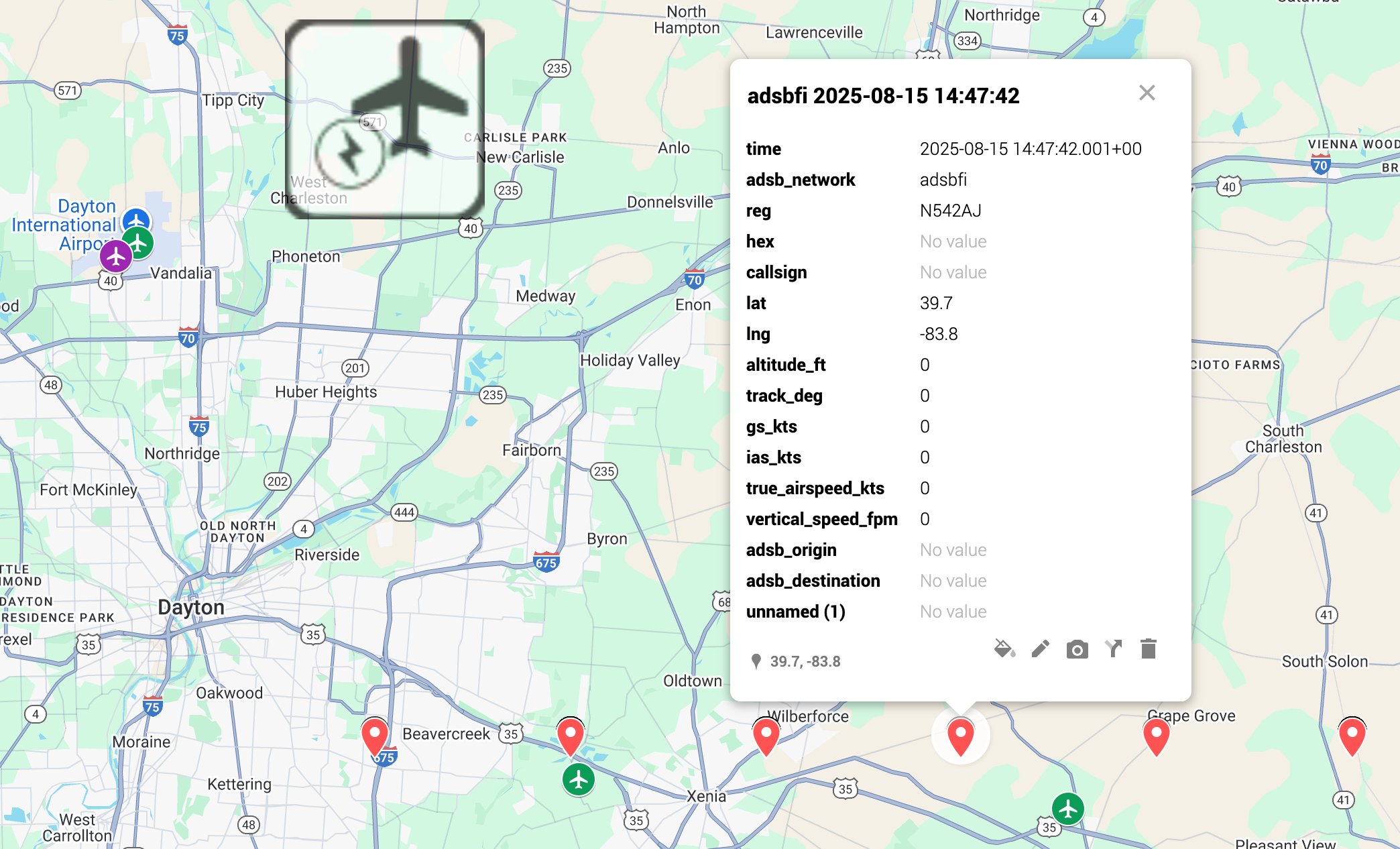
For instance, in last week’s EVTOL Flights Weekly I noticed that on August 15th 2025, we picked up lots of low precision activity data in and around the Dayton Ohio area.
Here’s what it looks like in the flight log:

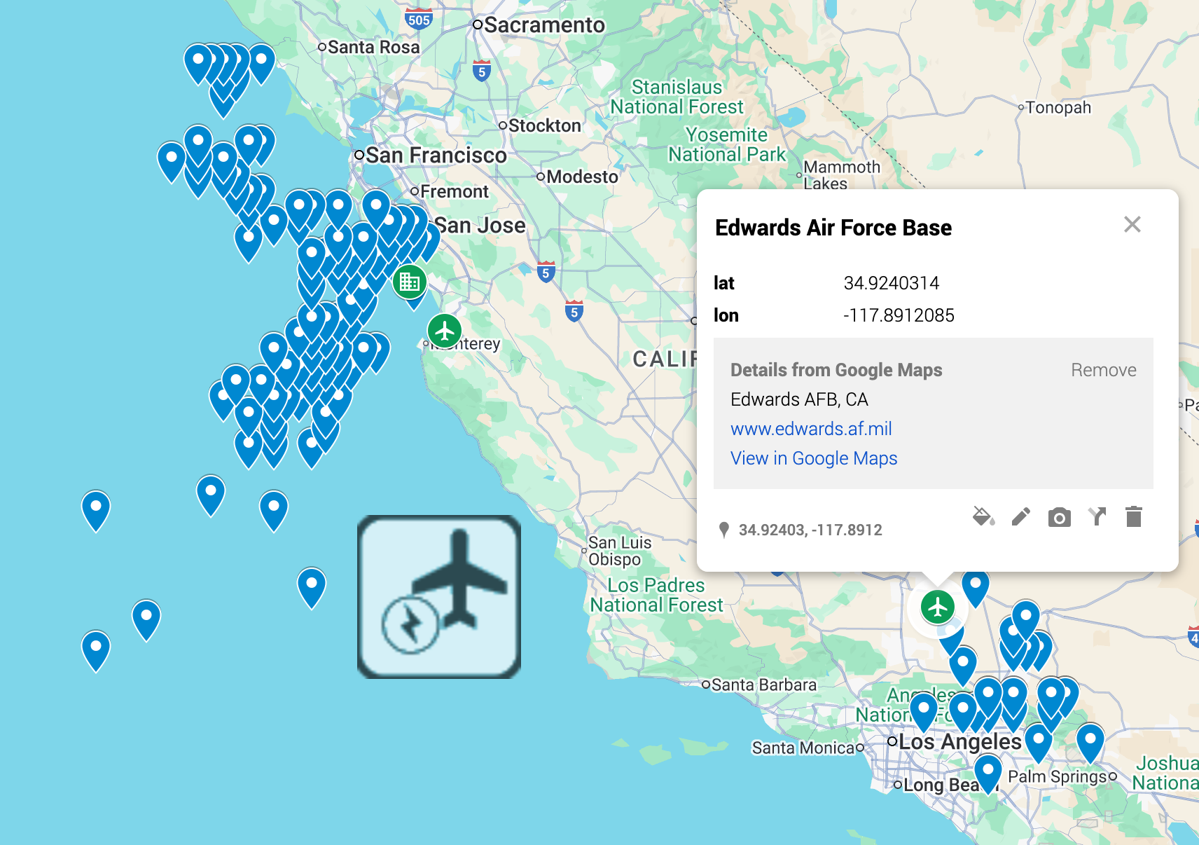
Since the precision is so low, you can see that the different locations appear evenly spaced out; the map is choosing the geographic center of each coordinate to place the marker.
To shed some light on this, let’s look at the other places we’ve found Joby tail registrations with low precision data. As you can see, there are clusters around where you’d suspect - Edwards Air Force Base, and Marina KOAR, though never right on top of those locations.
Oh, and also this map, showing the JAI30 where it has been reported in the air around Pendleton UAS base:
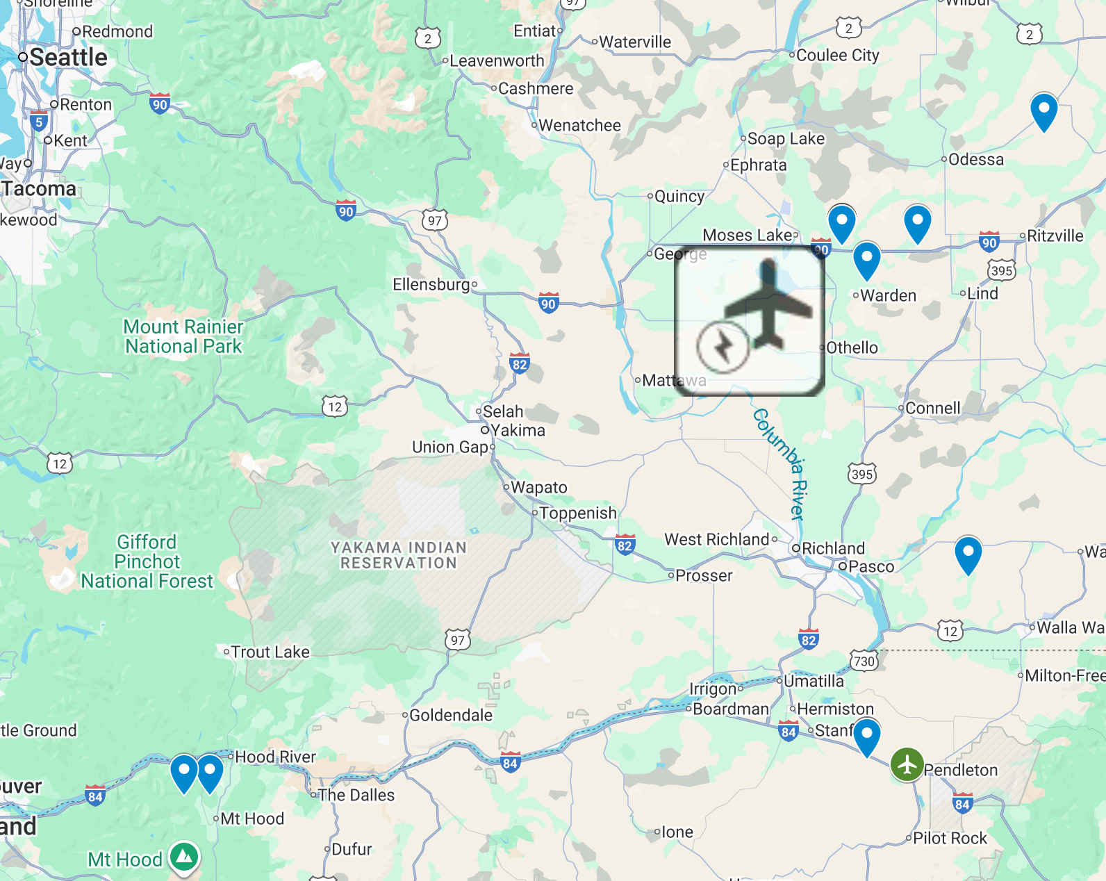
Last week I was calling this “Moses Lake”, but after a bit more research the JAI30 was flying out of Pendleton UAS range. Joby has tested aircraft at Moses Lake in the past, so this wasn’t so far off, but Pendleton is a better label for these activities.

Map showing all Joby low precision activity since Jan 1 2025
What to make of all this?
I’m really not sure.
When we get low precision data because the aircraft’s GPS is not feeding the transponder, perhaps the ADSB receiver nearest to the activity will end up choosing a location close to where the receiver is; explaining why we see these clusters of locations around known Joby test locations, but in the general direction of more populous areas (higher likelihood of being an ADSB receiver nearby). Or, over the Pacific Ocean, which makes less sense. Not sure here.
It could be that someone is powering up an iron bird, or just the transponder without the avionics suite, on a test bench, explaining why there is no GPS signal [possible?]
It could be that someone is feeding ADSBFi bad data on purpose so that rabbit hole prone ADSB nerds like myself will spend hours and hours analyzing (and now writing about) data to see what wild guesses they may come up with [seems unlikely]
It could be that there is an aircraft in the air flying out of Lewis Jackson Regional or Les Moyers Aerodrome that’s dialed N542AJ into their avionics, even though the FAA clearly states that N542AJ is no longer assigned to Joby. [least likely]
Discuss!
What do you think? Totally open to discussion on the SkyZero.io reddit where this has been posted!
Definitions
I try to use the same words for the same things when I can- here’s a longer definition of what I mean when I say them.
Geographic coordinate (coordinate)
A latitude longitude pair. We separate them in to precision categories:
Low precision; e.g.
36.0, -75.7we define low precision as a single decimal point.A single decimal point of precision means an 11.1 square km area according to this Garmin page on GPS precision.
When an ADSB data point does not have a high precision coordinate, often a low precision coordinate is provided in the
rr_lonandrr_latfields with a single digit of precisionThis page has more information on ADSB fields, such as rr_lon and rr_lat
Higher precision; e.g.
36.01985210726513,-75.66874426993044we define high precision as any coordinate with 6 or more digits of precision after the decimal (milimeter precision),
and medium precision as between 2 and 5 digits (1 km to 1 meter).
About half (52%) of our records are low precision, 16% are medium precision (good), and 32% are high precision (excellent). A
Activity
A contiguous sequence of aircraft observations:
with fewer than 15 minutes between this observation and the other observations in the sequence,
that refer to the same identifier (tail registration in most cases, though sometimes a hex code, and in rare circumstances a callsign).
Flight
An activity is promoted to a flight when it:
has at least one observation with a non-zero, non-ground altitude,
and at least one observation with a medium or high precision coordinate.
Data collection methodology
We connect to different ADSB aggregators for flight data
We continually expand ADSB coverage by adding more aggregators
Some aggregators provide origin and destination airports for us
When origin and destination aren't available we locate the nearest airport to the first spotting for origin, last spotting for destination
We collect aircraft registration data from FAA, Transport Canada, France's DGAC, and ADSB Exchange
We rely on high quality airport location data available publicly
We provide "kg CO2e emissions saved" calculation for fixed wing aircraft comparable to C172, and multiply flight duration x 88kg. When our duration figures are incorrect they tend to be smaller than actual, not larger, so this is a useful minimum, actual is likely higher.
We don't yet attempt to provide calcs for EVTol, partially because most EVTol flight today is mostly certification work
However, once they do begin flying non - certifications we are considering comparing against the Bell 407
Charger locations are accurate as per January 31, 2025, but we do not have an ability to update charger status automatically - please do not use this as a charger planning tool
Our database contains information from ADSB.lol (among other ADSB networks), which is made available here under the Open Database License (ODbL).